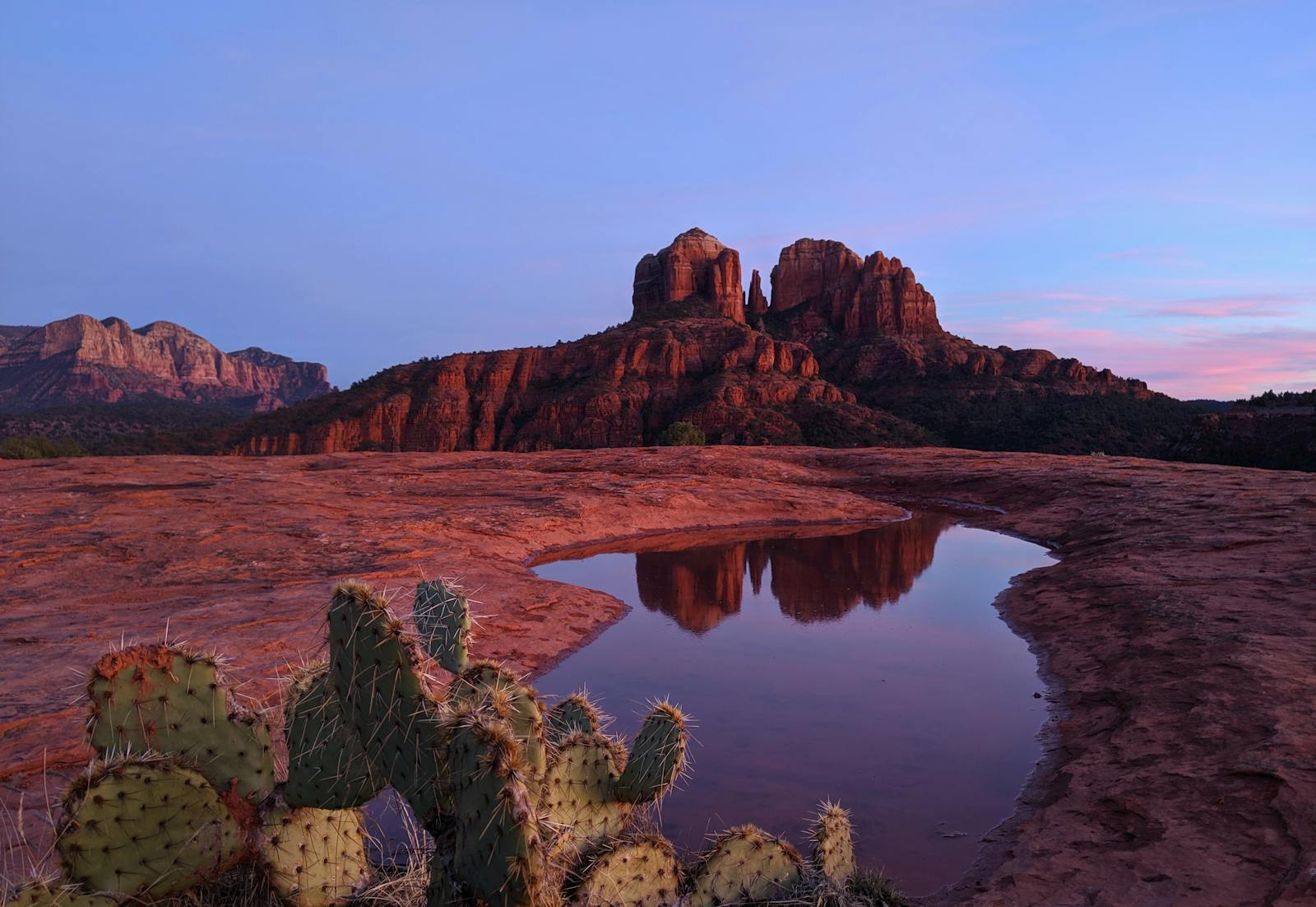
Sedona has two hikes that dominate every bucket list: Cathedral Rock, the most photographed formation in Arizona, and Devil's Bridge, the largest natural sandstone arch in the area. The comparison question — which one should I do, can I do both, which is harder — gets answered in vague platitudes almost everywhere online. This guide gives you the specific tradeoffs.
The core tradeoff no other comparison names directly: Cathedral Rock is a genuine scramble — short, intense, and time-sensitive because the trailhead lot holds 20 cars. Devil's Bridge is a longer, more forgiving hike to a dramatic destination, but its access logistics are uniquely complicated: either you need a 4WD vehicle for the short route, or you accept a 4.2-mile round trip on the standard 2WD approach, or you figure out the shuttle. Both trails require a Red Rock Pass. Neither is walk-up friendly on a spring weekend without a plan.
This comparison is based on hiking both trails in spring 2026. Distances, elevation figures, and parking details are sourced from the individual trail guides in this network — see the full Cathedral Rock guide and the full Devil's Bridge guide for single-trail depth.
Methodology
How this comparison was built and what was excluded:
- What was hiked: Both Cathedral Rock Trail (Back O' Beyond Trailhead approach) and Devil's Bridge Trail (Mescal Trailhead approach) were hiked in spring 2026 in roughly the same seasonal window — early May, with morning starts before 7am both days. Conditions were dry, trailheads were open, Red Rock Pass required at both.
- What the numbers come from: Trail distances and elevation figures were checked directly against the Coconino National Forest's official trail pages (fs.usda.gov) during a 2026-08 fact audit. Cathedral Rock Trail No. 170: 1.5 miles round trip, 669 ft gain. Devil's Bridge Trail No. 120: 1.6 miles round trip (371 ft gain) if you drive the full high-clearance FR152 road to the innermost trailhead; 4.0 miles round trip via the Mescal Trailhead; 5.8 miles round trip via the Chuckwagon/Dry Creek Vista Trailhead. These figures correct an earlier version of this page, which understated both the Mescal and Chuckwagon round-trip distances.
- What was excluded: Extended loop routes (Templeton Trail extension from Cathedral Rock; Brins Mesa extension from Devil's Bridge). Neither loop is compared here; each is covered in the individual trail guides.
- Photo timing: Photography window assessments are based on season-specific observation in spring 2026. Light conditions vary significantly by season; exact times shift with sunrise and sunset.
- Refresh cycle: Trail conditions, parking rules, and permit requirements change seasonally. This page will be refreshed at minimum annually, or when the Coconino National Forest updates access rules. Last verified: 2026-05-25.
At a Glance: Side-by-Side Trail Comparison
| Trail | Distance | Elevation Gain | Difficulty | Typical Time | Best Window | Parking Risk | Photo Window |
|---|---|---|---|---|---|---|---|
| Cathedral Rock | 1.5 mi RT | 669 ft | Hard (scramble) | 1.5–2.5 hrs | 6–8am or dusk | Very High — lot fills by 8:30am weekends | Sunrise from the notch; late afternoon for creek reflection below |
| Devil's Bridge (Mescal) | 4.0 mi RT | Not separately published by USFS | Moderate | 2–2.5 hrs | Early morning or weekday | Moderate — 4WD road; lot small | 9–11am light on arch from above; silhouette at sunset |
| Devil's Bridge (Chuckwagon) | 5.8 mi RT | Not separately published by USFS | Moderate | 3–3.5 hrs | Early morning or shuttle | High — Dry Creek lot fills by 8am weekends | 9–11am light on arch from above; silhouette at sunset |
Cathedral Rock: Short, Steep, and Unforgiving on Timing
Distance, Elevation, and What the Numbers Actually Mean
Cathedral Rock Trail is listed at 1.5 miles round trip with 669 feet of elevation gain, per the Coconino National Forest's official Cathedral Rock Trail No. 170 page. Those numbers are technically accurate and deeply misleading. The gain happens over 0.75 miles one-way — an average grade of roughly 17%, with sections much steeper. Above the trailhead, the trail becomes a genuine rock scramble requiring hand placements and deliberate foot placement on steep slickrock faces the Forest Service itself describes as ascending "over bald rock and in a shallow cleft with a few toeholds notched into the rock." The Forest Service rates it strenuous. Backpacker magazine has described it as more of a rock climb than a hike. Both are correct.
If you are expecting a trail you can hike in regular sneakers while checking your phone, this is the wrong trail. Trail runners with lug soles or low hiking boots are the minimum. No hiking poles above the creek — the scramble sections require both hands.
Parking Specifics and Arrival-Time Strategy
The Back O' Beyond Trailhead parking lot holds approximately 20 cars. On spring and fall weekends, it fills by 8:00–8:30am. An overflow lot exists further down Back O' Beyond Road, adding roughly 0.25 miles each way. By 9am on a busy weekend, the overflow lot may also be full.
The only reliable strategy: arrive before 7am. At 6am on a spring weekday, the lot is empty. At 7am on a spring Saturday, you have maybe a 50% chance of finding a spot. By 8am, you are parking on the street and adding significant walk time.
If you miss the window, consider the Templeton Trail approach from the Red Rock Crossing / Crescent Moon Ranch area — it adds about 2 miles round trip but uses a different parking area and gives you the famous creek-reflection photograph at the base. Or use the audio tour from your hotel and start with the Creek Crossing stop at Crescent Moon before the main trailhead scramble. The Cathedral Rock audio tour covers this exact logistics sequence.
The Creek Crossing
The standard Back O' Beyond approach begins with an Oak Creek crossing at Red Rock Crossing. This crossing is wet from roughly late February through June due to snowmelt — ankle to shin depth in normal conditions. Waterproof trail shoes or sandals you can get wet are the correct footwear choice in spring. The crossing itself is shallow and not dangerous, but it is unavoidable on the standard route.
Permit Requirements
No trail permit required. A Red Rock Pass is required to park at the Back O' Beyond Trailhead: $5 per vehicle per day, $15 per week. The America the Beautiful annual pass ($80) covers this and all other Red Rock Country fee sites. Crescent Moon Ranch day-use area (for the creek reflection photo) charges an additional $11 day-use fee.
Photo Logistics
Two distinct photo opportunities exist at Cathedral Rock, and most visitors only know about one of them.
From below (Red Rock Crossing): The famous postcard image — Cathedral Rock reflected in Oak Creek with cottonwood trees in the foreground. This is taken from the creek bank at the Crescent Moon Picnic Site, not from the trail itself. Optimal light is late afternoon: roughly 3–5pm in fall, 4–6pm in summer, when the sun lights the west face directly. A mirror reflection requires calm water; mornings are generally better for stillness.
From the notch (top of the trail): The saddle between the two main spires offers a view northwest across the entire Sedona basin and Verde Valley. Best photographed at golden hour from the south-side rock at the notch, looking back through the gap toward the valley. A sunrise arrival at the notch — timing your ascent to be at the saddle by first light — produces extraordinary light through the cleft. That means a 5:45–6am start from the trailhead in spring.
Connector and Extension Trails
The Templeton Trail branches from the main Cathedral Rock Trail at roughly the 0.3-mile mark. It wraps around the north side of the rock for about 1.7 miles before intersecting with the Baldwin and Hi Line trails. The Templeton section is soft red-dirt path, gently undulating, completely different in character from the scramble route. The junction with Templeton is where most hikers turn around; continuing west on Templeton to Oak Creek and back creates a loop of roughly 3 miles total and is covered in full on the Cathedral Rock audio tour.
When NOT to Do Cathedral Rock
- Summer midday: The exposed slickrock face throws back heat aggressively. Start before 7am or wait until after 4pm in June–August. Midday in summer is genuinely dangerous on this trail.
- After rain: Wet sandstone loses almost all friction. The scramble sections that feel manageable dry become genuinely hazardous wet. Check the weather and avoid the rock if it has rained within the last few hours.
- Monsoon afternoons (July–September): Lightning on the exposed rock face is a real risk. Storms build fast over the Mogollon Rim. Be off the high rock by noon in monsoon season.
- With children under 10: The scramble sections are too technical for young children who cannot follow instructions on steep rock. Bell Rock Trail is a better Sedona option for families with young kids.
Devil's Bridge: Moderate Hike, Complicated Access
Distance, Elevation, and Route Options
Devil's Bridge has three practical access options, and per the Coconino National Forest's official Devil's Bridge Trail No. 120 page, they are NOT close in length — the option you choose determines the length, difficulty, and parking situation of your day far more than earlier versions of this guide suggested:
Drive the full high-clearance road (shortest hike, roughest drive): Continuing on unpaved FR152 past the fork (high-clearance vehicle required) puts you at the Devil's Bridge Trailhead itself. From there it's just 1.6 miles round trip with 371 feet of elevation gain — the Forest Service's baseline figure for the trail.
Chuckwagon Trailhead (recommended for most visitors, standard 2WD): Park at the Dry Creek Vista Trailhead where the pavement ends, and hike in via the Chuckwagon Trail. Per the Forest Service, this adds 2.1 miles one-way of moderately easy rolling trail, for a total of about 2.9 miles one-way to the bridge — 5.8 miles round trip. Sandy desert wash and rolling trail with fantastic views. Budget 3 to 3.5 hours round trip at an average pace.
Mescal Trailhead (unpaved but generally 2WD-passable in dry conditions): Continue past the Chuckwagon turnoff to Long Canyon Road and the Mescal Trailhead. The Forest Service lists the round trip from here at 4.0 miles — shorter than Chuckwagon, but noticeably longer than the drive-all-the-way option.
Sedona free shuttle: Runs Thursday through Sunday, 7am to 5:30pm, from central Sedona to the Dry Creek Trailhead area. Eliminates the parking battle entirely and costs nothing, but drops you at the Chuckwagon approach — the longest of the three hikes.
Parking Specifics and Arrival-Time Strategy
The Chuckwagon/Dry Creek Trailhead lot fills by 7:30–8am on spring and fall weekends. On peak spring weekends (mid-March through late April), cars overflow onto Dry Creek Road by 8:30am. Parking on private property or blocking the road will result in a citation.
The realistic options if you want to drive: Arrive before 7am (the lot is usually available), or continue on to the Mescal Trailhead or the full high-clearance FR152 road if your vehicle and the road conditions allow it — both have smaller lots that see less traffic than Chuckwagon.
On weekdays, parking remains available until roughly 9am — a significant improvement over weekends. If your trip schedule allows Tuesday through Thursday hiking, the Devil's Bridge crowd situation drops dramatically.
Permit Requirements
No trail permit required. A Red Rock Pass is required at both the Chuckwagon and Mescal Trailheads: $5 per vehicle per day, $15 per week. The America the Beautiful annual pass covers this and all other Red Rock Country fee sites, including the Grand Canyon if you are doing a day trip from Sedona — it pays for itself immediately in that scenario.
Photo Logistics
The arch itself is 54 feet wide. The walking surface on top is roughly 10 feet across at the narrowest point. There is no railing.
The iconic shot: Taken from a side viewpoint about 30 feet off the arch, with a companion walking the arch against sky. This requires two people or a willing stranger — the queue culture at Devil's Bridge generally includes a "photograph yours, then mine" trade. Shoot at late morning (9–11am) for light on the arch surface; late afternoon backlights the subject for a silhouette against the sky.
The "reflection pool" image that circulates widely on social media is fabricated — there is no water at Devil's Bridge. The real arch needs no embellishment. The standard telephoto shot from the side viewpoint is genuinely dramatic without any enhancement.
Connector and Extension Trails
The Chuckwagon Trail connects Devil's Bridge to the Brins Mesa Trail system, which adds significant mileage if you want a longer day. The Mescal Trail also connects west to the Long Canyon Trail. Most visitors do Devil's Bridge as an out-and-back; the extension options are covered in AllTrails' GPS track if you want to plan additional mileage.
When NOT to Do Devil's Bridge
- Summer midday: The first mile runs through an exposed sandy wash with no shade. Starting after 9am in June–August puts you on the hottest section at the hottest time. 6am start is the practical minimum in summer.
- Monsoon afternoons (July–September): Lightning risk on the exposed slickrock shelf near the arch. Start early, be off the arch by noon in monsoon season.
- With children under 8: The arch has no railing and a significant drop. Children who cannot reliably follow instructions on exposed rock should stay with an adult at all times — or skip the arch walkout and photograph from below.
- With a standard SUV on the Mescal road: The sandy washes between the trailhead and the arch have stranded many vehicles. If you are not confident in your vehicle's clearance and 4WD capability, use the Chuckwagon route or the shuttle.
Combining Cathedral Rock and Devil's Bridge in One Day
Who Can Realistically Do Both
Doing both trails in a single day is achievable for hikers in moderate to good fitness with an early start and careful sequencing. Combined active hiking time is roughly 4.5 to 6 hours if you take Devil's Bridge via Chuckwagon (5.8 miles round trip), or closer to 3.5 to 5 hours via the Mescal Trailhead (4.0 miles round trip). On a spring day with manageable temperatures, the total outing — driving between trailheads, hiking both routes, time at each destination — runs roughly 7.5 to 9 hours via Chuckwagon, or 7 to 8 hours via Mescal.
This is not a casual day. If anyone in your group struggles on rocky terrain or has knee or ankle issues, pick one trail rather than combining. Cathedral Rock is harder and should be weighed accordingly.
The Order That Actually Works
Start at Cathedral Rock, 6am. The Back O' Beyond Trailhead lot is available before 7am on most spring weekends. Cathedral Rock takes 1.5–2.5 hours. You are done and driving away before the lot fills completely.
Devil's Bridge next, 9–10am. By the time you drive from Cathedral Rock (about 20 minutes to Dry Creek Road), the Chuckwagon lot may be full. Arrive early enough, or continue to the Mescal Trailhead (shorter hike) if the road conditions and your vehicle allow it, or use the free shuttle from town. Devil's Bridge takes 3 to 3.5 hours from the Chuckwagon Trailhead (5.8 miles round trip) or about 2 to 2.5 hours from the Mescal Trailhead (4.0 miles round trip).
Reversing the order is harder because Cathedral Rock's lot fills faster and earlier than Devil's Bridge's. If you do Devil's Bridge first, the Cathedral Rock lot is likely full by the time you arrive.
Water and Fuel Math
Carry 2 liters minimum per person per trail — 4 liters total for a double-day. There is no water on either trail. Bring snacks or a meal for between trails; Sedona's food options on AZ-179 are convenient for a mid-day stop. Refuel before you start the second hike, not after.
If you would rather not deal with the driving and logistics of two separate trailheads, consider a guided Sedona day trip that covers both formations and handles the parking. Viator's Sedona day trip category has options that drive you between sites if you'd rather not navigate it yourself.
In Summer
Combining both in summer is only feasible with a very early start — on the Cathedral Rock rock face by 6am means finishing by 8am before the worst heat. Devil's Bridge in summer means finishing the arch by 10am. Both trails are exposed; the combined logistics in summer heat are genuinely demanding. Unless you are an experienced desert hiker, consider doing one trail per day in summer and using the cooler morning for each.
What AllTrails Has — and What It Doesn't
AllTrails is the right tool for turn-by-turn GPS navigation on both trails. The app has reliable offline tracks for both Cathedral Rock and Devil's Bridge, recent user-posted trail conditions reports (especially useful after rain or snowmelt), and a searchable photo library that shows actual current conditions rather than stock imagery. Download the offline map before you leave cell range — both trailheads have spotty service.
What AllTrails does not have: named-author editorial perspective, parking-time math that is current for this season, or an honest framing of which trail is appropriate for which hiker. The star rating system tends to skew positive because casual first-time visitors who had a good day leave 5-star reviews regardless of whether the trail matched their fitness level.
It also doesn't have the audio-tour cross-link that this network does. The Cathedral Rock audio tour covers the full loop including the Crescent Moon creek stop and the Templeton Trail extension — 75 minutes of GPS-triggered narration that covers the geology, the vortex context, and the photo sequence in real time as you walk. That is a different product from a trail map with user reviews. Both have their place.
Our recommendation: Use AllTrails for GPS navigation. Use this comparison for the planning and logistics decisions. Use the individual trail guides for single-trail depth. Use the audio tours as your in-pocket guide on the trail itself.
Want the Trail Story Without the Parking Stress?
The Cathedral Rock audio tour walks you the full loop — Crescent Moon creek stop, the trailhead scramble, the vortex notch, and the Templeton Trail back — with GPS-triggered narration covering the geology, the vortex tradition, and the photo sequence. It costs $19 and starts from your phone at the trailhead. That is the same formation jeep tours photograph from $180 per person below.
The Devil's Bridge + West Sedona audio tour covers the Mescal Trailhead approach, the social-trail confusion junction most guides skip, the arch photo logistics, and the return loop. Same $19 format. Start anytime, no booking required, no waiting for a group.
For both trails: the audio tour is how you get the guide-quality context — geology, history, what you're looking at and why — without coordinating around a group tour schedule or paying a premium. The parking problem remains yours to solve, but the in-trail experience is covered.
Cathedral Rock Audio Tour
5-stop GPS loop: Crescent Moon, trailhead, notch, Templeton Trail, west creek crossing. Geology, vortex context, photo sequence. $19. Start anytime.
Get the Cathedral Rock TourDevil's Bridge + West Sedona Tour
Mescal Trailhead approach, the arch, photo logistics, and the return. Real parking math, real trail context. $19. Start anytime.
Get the Devil's Bridge Tour